
Latitude and longitude are geographical coordinates used to identify locations on Earth’s surface. They provide a universal reference system that helps people locate cities, countries, mountains, oceans and other geographical features.
Modern navigation, digital maps, geographical research and surveying all depend on coordinate systems. Understanding latitude and longitude also makes it easier to read maps and interpret geographical information.
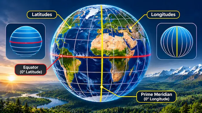
This guide explains how both coordinate systems work, their differences and how to use them to understand locations around the world.
What Are Geographical Coordinates?
Geographical coordinates describe the position of a location using angular measurements.
The two main coordinates are latitude and longitude. Latitude identifies a location north or south of the Equator, while longitude identifies its position east or west of the Prime Meridian.
Together, these measurements provide a geographical reference for locating places.
Coordinates are usually written in degrees. They can also include minutes and seconds or use decimal degrees.
What Is Latitude?
Latitude measures the angular distance of a location north or south of the Equator.
The Equator represents 0 degrees latitude. It divides Earth into the Northern Hemisphere and Southern Hemisphere.
Latitude values extend from 0 degrees at the Equator to 90 degrees at each pole.
- 90° North represents the North Pole.
- 90° South represents the South Pole.
- 0° represents the Equator.
Lines of latitude are also called parallels because they run parallel to the Equator.
Important Lines of Latitude
Several important latitude lines help explain Earth’s geographical and climatic regions.
The Equator – 0°
The Equator passes around the middle of Earth and divides the planet into two hemispheres. Regions near it generally receive strong sunlight throughout the year.
Tropic of Cancer – Approximately 23.5° North
The Tropic of Cancer marks the northernmost latitude where the Sun can appear directly overhead at solar noon.
Tropic of Capricorn – Approximately 23.5° South
The Tropic of Capricorn marks the corresponding southern limit of the Sun’s direct overhead position.
Arctic Circle – Approximately 66.5° North
The Arctic Circle marks the approximate southern boundary of the region where at least one day each year can experience continuous daylight or darkness.
Antarctic Circle – Approximately 66.5° South
The Antarctic Circle marks the corresponding boundary in the Southern Hemisphere.
These lines are important geographical references used to describe Earth’s major climatic and astronomical zones.
What Is Longitude?
Longitude measures the angular distance east or west of the Prime Meridian.
The Prime Meridian represents 0 degrees longitude and passes through Greenwich in London, England.
Longitude values extend up to 180 degrees east and 180 degrees west.
Unlike latitude lines, longitude lines meet at the North and South Poles. They are also called meridians.
The 180-degree meridian lies roughly opposite the Prime Meridian and is associated with the general location of the International Date Line, although the date line does not follow it exactly.
The Prime Meridian
The Prime Meridian provides the starting reference for measuring longitude.
It was internationally established as the standard reference meridian in 1884.
It also provides the geographical basis for the historical Greenwich Mean Time reference system.
Today, global timekeeping uses Coordinated Universal Time, or UTC, which is maintained through modern atomic timekeeping standards.
The Difference Between Latitude and Longitude
Latitude and longitude work together, but they measure different geographical directions.
| Feature | Latitude | Longitude |
|---|---|---|
| Measures | North or south | East or west |
| Reference line | Equator | Prime Meridian |
| Range | 0° to 90° N or S | 0° to 180° E or W |
| Line name | Parallels | Meridians |
| Shape | Parallel circles | Lines meeting at the poles |
| Main purpose | North-south position | East-west position |
A location needs both coordinates to identify its position accurately.
How to Read Geographic Coordinates
Coordinates can be expressed in different formats.
The most common formats include degrees, minutes and seconds, and decimal degrees.
Degrees, Minutes and Seconds
This format divides each degree into 60 minutes and each minute into 60 seconds.
For example:
40° 42′ 46″ N, 74° 00′ 21″ W
This format represents a location in New York City.
The letters N and W indicate that the location is north of the Equator and west of the Prime Meridian.
Decimal Degrees
Decimal degrees express the same coordinates using decimal numbers.
For example:
40.7128° N, 74.0060° W
Positive latitude values generally indicate locations north of the Equator, while negative values indicate locations south of it.
Positive longitude values generally indicate locations east of the Prime Meridian, while negative values indicate locations west of it.
How Latitude and Longitude Work Together
Latitude and longitude form a coordinate grid across Earth’s surface.
Imagine a map with horizontal and vertical reference lines. A location can be identified by finding the intersection of its latitude and longitude.
For example, the coordinates of a city can be entered into a digital mapping system to display its geographical position.
This method is useful because place names may be shared by different locations, but geographical coordinates provide a more precise reference.
Coordinates are also used to identify points in remote areas where there are no roads, buildings or recognizable landmarks.
Why Latitude and Longitude Are Important
Geographical coordinates support many activities.
Navigation: Ships, aircraft and vehicles use coordinate information to determine positions and plan routes.
Digital mapping: Mapping applications use coordinates to display locations and provide directions.
Surveying: Land surveyors use geographical reference systems to measure and map properties and landscapes.
Weather forecasting: Meteorological systems use geographical coordinates to identify weather observations and forecast locations.
Scientific research: Researchers use coordinates to record the positions of environmental observations, geological samples and wildlife.
Emergency services: Location information helps emergency teams identify where assistance is needed.
Latitude, Longitude and the Global Positioning System
The Global Positioning System, commonly called GPS, is a satellite-based navigation system.
GPS receivers calculate their positions using signals from multiple satellites. These calculations can provide latitude, longitude and elevation information.
Other satellite navigation systems include Galileo, GLONASS and BeiDou.
Together, these systems support modern navigation, transportation, mapping and location-based applications.
It is important to understand that latitude and longitude are geographical coordinates, while GPS is one technology used to determine those coordinates.
Frequently Asked Questions
What is latitude in simple words?
Latitude measures how far north or south a location is from the Equator.
What is longitude in simple words?
Longitude measures how far east or west a location is from the Prime Meridian.
What is the Equator?
The Equator is an imaginary line at 0 degrees latitude that divides Earth into the Northern and Southern Hemispheres.
What is the Prime Meridian?
The Prime Meridian is the reference line at 0 degrees longitude. It passes through Greenwich, England.
Do latitude and longitude use degrees?
Yes. Both coordinates are measured in degrees and can also be expressed using minutes, seconds or decimal values.
Can two places have the same latitude?
Yes. Many places share the same latitude but have different longitudes.
Can coordinates identify an exact location?
Coordinates can identify a geographical position with varying levels of precision, depending on the coordinate format and measurement accuracy.
What is the difference between GPS and latitude and longitude?
Latitude and longitude describe geographical positions. GPS is a satellite navigation system that can calculate those positions.
Understanding the Global Coordinate System
Latitude and longitude provide a consistent way to describe locations across the planet. They connect geographical maps with navigation systems, scientific research and digital technology.
Learning how these coordinates work makes it easier to understand maps, identify locations and explore the spatial organization of Earth.